- Press Office
- Blogs and More
- The sun, the seasons and the navigation on the sea - Blogpost 7 from RV SONNE, March 26, 2018
The sun, the seasons and the navigation on the sea - Blogpost 7 from RV SONNE, March 26, 2018
On Board RV SONNE, Chile
March 26, 2018
Blog #7 - The sun, the seasons and the navigation on the sea
A few days ago on 20 March was the beginning of autumn in the southern hemisphere. Almost unnoticed aboard Research Vessel Sonne we are now in the tropics. After three weeks we have completed half of our voyage and have been able to collect many samples and data from the depths of the Atacama Trench. Even at night the crew is working to operate the winches, deploy or recover our equipment from the Atacama Trench. When the instruments arrive on deck at three o´clock in the morning, the scientists are waiting to process their valuable samples immediately in the cold room. Technical problems are usually solved quickly and so far our expedition has been very successful.
Spring and Autumn
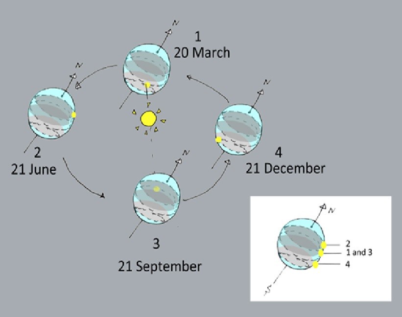
While spring starts in the northern hemisphere, autumn begins here in the southern hemisphere. On 20 March was the equinox, the day when the sun is at its zenith at the equator at noon. Viewed from the northern hemisphere, the sun then continues to rise north during the year and the days get longer. This will last until the 21st of June, the beginning of summer. Then the sun stands at noon on the Tropic of Cancer at 23.4 degrees north and then moves back towards the equator. Around September 21, the same game starts again. The sun is in the equator, and it is again equinox. The underlying astronomical event is based on the fact that the Earth's axis is tilted by about 23.4 degrees with respect to its orbit around the sun and thus provides for changing solar irradiation periods, just the seasons.
We are a few nautical miles north of the Tropic of Capricorn at 23.4 degrees South off the coast of Chile near Antofagasta. The names Cancer and Capricorn stand for the signs of the zodiac in the sky. This is the sector of the sky where the sun was during ancient times as seen from Earth. Nowadays the whole system has shifted a bit. The English terms Tropic of the Cancer" and "Tropic of the Capricorn" are reminiscent of the ancient Greek term "tropoi heliou" for tropic. The tropics are the area between the two tropics.
Classic navigation
The German research vessel Sonne is equipped with state-of-the-art navigation devices and permanently in contact with the mainland via satellite antenna. With their diesel-electric engines, the ship can be kept exactly in position, because anchoring would not be possible at a water depth of over 8000 meters. Long before the introduction of GPS and map plotters, sailors had developed techniques to determine their own location at sea. Contrary to popular belief, danger is not out there on the high seas, but rather near the coast, where shallows and reefs meant the end for some ships and their crew. That's why beacons and navigational signs show the way.
Compass, sextant and bearing plate
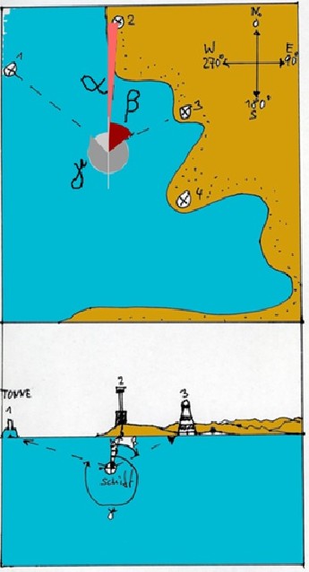
For good seamanship, for every seagoing ship it was a must to have nautical charts, a sextant for precise measuring angles, compass, lot, log, bearing plate and manuals with data on tides, currents and wind conditions. Near the coast sailors determined their positions by measuring the angle (or bearing) of two visible objects which are recorded on the nautical chart. After plotting these bearings to the nautical chart, the own position could be determined at the intersection of the two plotting lines. In addition, conclusions can be drawn from the measured water depth in comparison with the depth lines of the nautical chart. Alternatively, if a lighthouse was in range, the listed height data from the lighthouse directories were taken. If the height of the beacon is known, it is possible to calculate the distance to this by determining the angle lighthouse top, ship and beach. The own position must be on the arc around the lighthouse. With a second intersecting line from another bearing the own position could be determined.
Without horizon no astronavigation
With a sextant and a precise clock, the height of sun, moon, and stars and as measured by their angles to the horizon were used to calculate plotting lines similar to the method of the lighthouse elevation angle. The ship´s position is at the intersection of two lines calculated from the measured angles. A skilled observer can achieve an accuracy of half a nautical mile. This method works only, if the horizon is visible. So during the day the sailors used the celestial objects like sun and moon, the stars and planets only in the twilight phase when the horizon is still visible. When the sky is overcast, the sailors had to estimate their position from their speed over ground and the compass heading and an offset by wind and current. This method already helped Columbus across the Atlantic. It is interesting to note that even today's astronavigation is based on the erroneous assumption that the earth is in the center and the sun, moon and stars are orbiting around them. Since all movements are relative, nevertheless correct results come out. And that is valid for centuries.
Specific questions addressed during this cruise are:
- What are the sedimentary processes providing food for the hadal community in the Atacama Trench?
- How do abundance, diversity and community structure of microorganisms, meio- and macrofauna in the Atacama Trench differ from those in less productive trenches and nearby abyssal and shelf sites?
- What are the general biogeochemical characteristics of the surface and deep sediment and water column in the eutrophic Atacama Trench?
- Which mineralization pathways are responsible for organic matter breakdown in the eutrophic Atacama Trench?
- How efficient are microbial communities operating at extreme hydrostatic pressures in mineralizing organic material as compared to their shallower counterparts? And to what extent do specialized, yet unknown extremophile microbial communities mediate these processes?
Further information
More details about the project from the University of Southern Denmark.
More pictures related to the project.
Ronnie N Glud at Danmarks Radio (in Danish)
RV SONNE is a modern German research vessel sailing mainly in the Pacific Ocean.
More information about the ship here.


